Children are remarkably adept at using and making maps and appear to develop spatial awareness from an early age. The maps that they draw not only provide a fascinating insight into their imaginary world and but also indicate the places that they value and their ideas about their environment. There is considerable discussion about the stages which children go through as they develop their mapwork skills. What seems certain is that children find maps a valuable way to communicate to others and to express their ideas about the world.
Children develop a knowledge of their immediate surroundings from a very early age. The ability to find food, water and shelter are key survival skills and even the youngest babies know that their mother will provide them with milk and appreciate that their parents are a source of safety and support. As they grow older, they find out more about the world around them, quickly learning to shuffle, crawl, and then to walk to places of interest, albeit rather unsteadily at first. These early activities all contribute to the toddler’s growing sense of spatial awareness and provide foundations for their later map making.
It is significant that long before they can walk or speak, young children form images of the world in their heads. Equally, young children spontaneously start to draw pictures of places which show the relationships between different elements long before they can write. Some 50 years ago, Coleman and Balchin (1966) argued that ‘graphicacy’, or the ability to recognise spatial relationships, deserved to rank alongside oracy, literacy and numeracy as the ‘fourth ace’ in the pack which underpins educational achievement. Howard Gardner’s theory of multiple intelligences (1982), neurological research into active learning (Fischer 2009) and ideas about embodied cognition (Lucas and Claxton 2010) all lend support to this proposition.
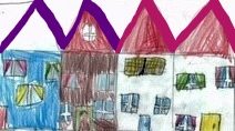
Young children’s drawings of places often provide a fascinating insight into an imaginary world in which fact and fantasy play out in complicated ways and in which ideas change and evolve spontaneously along with shifts of mood and inclination. Children find it natural to communicate in images and they draw either manually or electronically all manner of maps to show stories, events, routes and unknown places as well as to give expression to their hopes and fears. These ‘informal maps’ are highly personal and talking to children about what they have shown on their maps is essential if we are to understand what they represent (Figure 1).
There have many attempts to identify a progression in formal mapping skills but this is fraught with difficulties. Certainly children need to be familiar with basic conventions such as symbols, scales, orientation and co-ordinates if they are to interpret the maps they see around them, but when it comes to putting learning into a sequence there are fundamental disagreements. Is an overhead, plan view more sophisticated than a side view, for example? There are arguments on both sides and much depends on the context. One way to side-step this dichotomy is to see that children are exposed to a range of ‘formal’ adult maps all of which will feed their ideas and provide models to which they can respond.
There is a considerable literature about how best to promote children’s mapwork skills. One widely acknowledged finding is that environmental experience (particularly free-range exploration without adult supervision) has a beneficial impact. It is also important to see that map skills are developed in context rather than in isolation. As with other aspects of learning, children perform better if they see mapwork as being (a) meaningful and (b) fun. There are many different ways of making mapwork enjoyable ranging from using sticks to record a journey in the local area to creating edible maps of distant places. Hopefully contributing to the ‘Meaningful Maps’ project will also prove rewarding to those who take part as it attributes further value and significance to an activity which many young people find naturally worthwhile.
© Dr Stephen Scoffham July 2017
References
Balchin, W and Coleman, A. (1966) ‘Graphicacy Should be the Fourth Ace in the Pack’ in
Cartographia http://www.utpjournals.press/doi/abs/10.3138/C7Q0-MM01-6161-7315
Fischer, K. (2009) ‘Mind, Brain and Education: Building a Scientific Groundwork for Learning and Teaching’ in Mind Brain and Education 1;3-16
Gardner, H. (1982) Frames of Mind, New York: Basic Books
Lucas, B. and Claxton, G. (2010) New Kinds of Smart, Maidenhead: Open University Press
See also Primary Geography 2011, No 73 (focus on graphicacy) and Progression in Mapping www.digimapforschools.edina.ac.uk